|
KONO SCHOOL
View Full-size Image Kono Language
The Kono people (pronounced koh noh) is a major ethnic group in Sierra Leone at about 7.6% of the country's total population. Their homeland is the diamond-rich Kono District in south-eastern Sierra Leone. The Kono are primarily diamond miners and farmers.
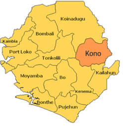
Brief History of Kono DistrictKono District is found in the eastern region of Sierra Leone. Kono district comprises of 14 chiefdoms divided into 70 sections, nine (9) political constituencies and 24 wards. It shares boundary with Tonkolili district on the west, Koinadugu on the North - North West, neighbouring Republic of Guinea on the East; Kailahun district on the South East and Kenema district on the South-South western boundary. The district is named after the tribe ‘Kono’ whose heritage is traced to be the first settling migrants from Mali through Guinea as part of a wider Mande migration. The Kono people are the descendants of Mali/Guinean migrants who are said to have settled in what is now Kono District in the mid-16th century, however there is archaeological evidence of settlement in Kono District as far back as 2200 B.C. Some sources claim that the Kono people were direct descendants of the Via, others the Mandingo. Both Narratives could be true as Kono migration can be seen in the wider context of migration of Mande speaking ethnic groups that was occurring during that period which save the break-up of large groups into smaller ones that formed their own identity and settled in various parts of Africa. The Kono people were once a powerful people in Mali and Guinea. They migrated to Sierra Leone as peaceful hunters. The first three chiefdoms founded by them were: Lei, Sandor and Soa- these are the three largest Chiefdoms in Kono District to which most if not all ethnic Konos can trace their root in Sierra Leone. Kissi and Kuranko also have their origins traced to some border areas of the district. Attacks from the related Mende people forced the Kono to seek refuge in the Koranko territory (another related group) to the north, where they were allowed to farm the land. The Mende eventually moved further south, and the Kono returned to their own land in the south-east. Population: The Kono people (pronounced koh noh) is a major ethnic group in Sierra Leone at about 7.6% of the country's total population. Predominantly, Kono is a cosmopolitan community. The Kono people speak the Kono language as their first language and is the most widely spoken language among the Kono people. The tribe was split during partitioning of Africa by European colonists and part of the tribe still exists in neighbouring Guinea. Eyewitness accounts also plot speakers of an almost identical language as far afield as Burkina Faso and Ivory Coast. Their homeland is the diamond-rich Kono District in south-eastern Sierra Leone. While the district is known to date to have the largest deposit of diamonds in Sierra Leone, the population is equally involved in agricultural activities. Kono district is the home of the largest deposit of both alluvia and kimber and alluvia diamonds mind in Sierra Leone. Added to this treasure, about 65% of the land mass of this district is richly endowed for agricultural productivity. Specifically, there are only six active mining chiefdoms (Gbense, Tankor, Nimikor, Nimiyama, Sandor and Kamaa) out of the fourteen chiefdoms. The rest have agriculture as the mainstay of their inhabitants. Additional to diamonds are large deposits of gold in the Nimini Hills that hover over Nimikor and Nimiyama chiefdoms, and the Kooe Hill dividing Soa and Gbane chiefdoms, has large deposit of uranium, also exist in these last two chiefdoms extending to surrounding chiefdoms. Although Tonkoli to have the largest deposits of gold in the county, much of it falls in the B - C grade; whereas Kono boasts of large quantities of grade A – B gold deposit. With the amount of income generated from the district from medium and large-scale diamond mining companies, Kono is certainly a significant contributor to the national economy. A proportion of the inhabitants and other Sierra Leoneans from other parts of the country are also involved in small scale mining activities, mostly as illicit miners. Climate & Topography: Comparative to most other parts of Sierra Leone, Kono is situated at a high altitude, enjoys cooler temperatures for most part of the year, a feature it shares with Kabala in the North of sierra Leone that is so similarly located. There are two main seasons - the dry season which starts in November through to May, and the rainy season from May to October. There have been seasonal shifts in recent years with rain being experienced in the country. Its average temperature is about 26 degrees centigrade ranging between 26 and 33 degree during the year. Kono district enjoys an average rainfall of approximately 2000 and 3000 millimetres. Its vegetation is mostly savannah and brush secondary growth with patches of evergreen forest. The vegetation dictates the kind of economic activity in the different parts of the district. http://en.wikipedia.org/wiki/Kono_people (20/03/2015) Map of Kono District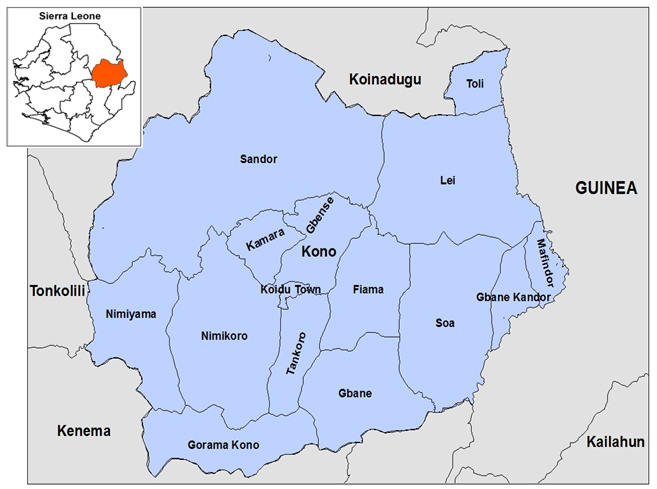
The Months of the Year Translated in Kono Language
The Days of the Week Translated in Kono
Names of Chiefdoms, Paramount Chiefs |
| NO | CHIEFDOM | PARAMOUNT CHIEF (PC) | CHIEFDOM SPEAKER |
| Fiama | Sahr Yongai Kontaday Mbriwa | S. A. G. Fomba | |
| Gbane | Aiah Bindi Feinfa Gongor | Allieu Konkuwa (Ag) | |
| Gbane Kandor | Sahr Edward M'bawa | Kwigba K. Sansie | |
| Gbense | Sahr Korgbende Kaimanchende | Aiah M. Kamanda | |
| Gorama Kono | Sahr Cyrus Ngebuva Konobundor | Kai William Konoboy (Ag) | |
| Kamaa | Aiah Melvin Njekiah II | Aiah Umaru Samuga (Ag) | |
| Lei | Fengai Mani | Joseph Mbowa (Ag) | |
| Mafindor | Abu M'bawa Kongbora | S. A. Suluku | |
| Nimikor | Aiah Denton Bona Foamansa III | Abdulai Komasi | |
| Nimiyama | George Bockarie Torto | Philip Koroma | |
| Sandor | Sheku Ahmed Tejan Fasuluku III | F. T. Kakamoi (Ag) | |
| Soa | Tamba Emmanuel Foryoh | Martin T. Kawoh | |
| Tankor | Paul Ngaba Saquee V | Sahr Borbor Gando | |
| Toli | Abu Duramani Soloko | Tamba B. K. Lansana |
Brief Chiefdom History
Fiama: This chiefdom traces its history to Aiah Kontandey M’briwa, a warrior who established himself in the area. Aiah is likely to have arrived with Kaimachiende M’ba, of Gbense chiefdom. A son of Aiah, Sahr Kontandey M’briwa, was head of the area at first contact with the British and broke off from Gbense to lead in independent chiefdom in 1913. The current chief is Sahr Youngai. He was elected in 2002. The previous chief, Sahr Sanga M’briwa was murdered during the war in 1993.
Gbane: This chiefdom traces its origin to two Kono warriors who existed during the 19th century. There is no story of them migrating from anywhere, but the Konos, part of the Mande language group, are thought to have been part of the Mane migration from Mali during the 16th century. Ngobu Kakpata, who settled at Tombodu Mainfe in present day Mongor section. His deputy was Fenfa, who stayed at Kondendu. The first chief of the chiefdom was Ngobu Nyandemoqui, son of Kakpata, who was first to be recognized by the British. The present chief is Aiah Bindi Fenfa Gongor, a Muslim, who was elected in 2010. Sahr Nyandemoqui III, the paramount chief during the war, fled the chiefdom for the duration of the war. Nyandamoqui means “fine leopard”.
Gbane Kandor: This chiefdom traces its origin to a warrior named Mamina, who lived during the 19th century. Mamina is said to have been born in Fanda, within the chiefdom, and took the region from other residents in a great battle, causing them to flee to present day Guinea. He hid in the Konogortan hills around the chiefdom and attacked from above. He was succeeded by Kamachi M’bawa, who was recognized as the first paramount chief by the British. The current chief is Sahr Edward M’bawa, a Kono and Muslim. He was elected in 2005. The chiefdom only has one ruling house. Tamba Fia M’bawa was chief during the war, and he fled briefly in 1997. He returned in 2000 and died in 2003.
Gbense: This chiefdom surrounds Koidu town, the largest in the diamond mining area of Kono. It traces its origin to a warrior named Kaimachiende M’ba, which means “fearsome” in Kono. During the 19th century informants claim he also held authority over Gbense chiefdom and of the adjacent chiefdom of Fiama. He was arrested by the British during the hut tax rebellion, allowing Tao Kabba to take over. After Tao Kabba was arrested again for financial fraud, Fiama split off from Gbense in 1913, led by Sahr Kontandey M’Briwa, who was perhaps a subordinate to Kaimachiende. Koidu was a site of intense fighting during the RUF rebel war, and the chief during the war was forced to flee in 1998. The chiefdom currently receives revenues from small-scale artisanal diamond mining. The current chief is Sahr Fengai, a Kono elected in 2002, who has his headquarters at Yardu Village.
Gorama Kono: Gorama Kono traces its origin to a group of Kono warriors who are thought to have conquered the area during the 19th century. The warriors were led by Konobundor, and included Dugbawa Manyeh, Sogboh, and Kanda. Konobundor was the eldest and became the leader when there was peace. The current chief also has the name Kono Bundor and was elected in 1984. He fled briefly during the war. Kono Bundor - This house traces the history of Bundor, who was the first chief to be recognized by the British.
Kamaa: This chiefdom traces its origin to a warrior named Hindowa Ngandi who dislodged the “Kamaranos” from the area. Informants say their local interpretation of Kamara is that it means “someone who does not eat baboon”. The first chief to be recognized by the British was Sumana Tieh, a son of Hindowa. The current chief is Aiah Melvin Ngekiah II, a Muslim Kono elected in 2003. The chief during the war S.G.M. Fania fled in 1992 and died in the United Kingdom in 1999.
Tieh - This house traces the lineage of Sumana Tieh the first chief to be recognized by the British. Their headquarters is at Tombodu.
Lei: This chiefdom traces its origin to Kogbanda, a Kissi, warrior who migrated from present day Guinea. The story is that there were many chiefs in the area at the time the British arrived. Kogbanda was the only one brave enough to face them, and so was the first to be recognized as chief. His house, the Mani family, has ruled ever since. Sahr Keleti Mani, was elected in 2003. His predecessor, Aiah Alpha Mani, fled the chiefdom in 1992 during the war before dying of natural causes in 2001. The current Paramount chief for Saima's predecessor is Paramount Chief Fengai Mani who survived Paramount Chief A. A. Mani.
Mafindor: Mafindor chiefdom borders Guinea along the river Malee. It traces its history to a warrior named Suluku Handupor, a Kono who led the chiefdom throughout the 19th century and was recognized by the British as chief in 1891. In a famous battle, which likely occurred in the 1880s, he deterred the Sofa from the north led by Mori Turay. After the death of chief Sahr Lamin Musa in 1948, this chiefdom was briefly administrated by the chief of Gbane Kandor chiefdom. It became independent again under the leadership of chief Kekura Lyod Musa in 1959. The current chief is Abu M’bawa Kongorba, who was elected in 1986. He played a leadership role in the early part of the war, joining the Kono Council of Paramount Chiefs organized with the consent of the NPRC in 1994. He fled to Guinea during the war between 1997 and 2001.
Nimikor: This chiefdom traces its history to a Kono warrior named Foamansa Matturie. He was recognized as first chief by the British in 1876. His descendants, who have formed two families, have alternated rule over the chiefdom. The current chief, Aiah Denton Bona Foamansa III, of the Bona family, was elected in 2006.
Matturi - This house traces the lineage of Foamansa Matturie and has its headquarters at Sahr Fillie village. Bona - This house originated from Dudubona, who was related to the Matturi house through marriage, and ruled after Matturi until 1981. They have their headquarters at Bonadae village.
Nimiyama: Nimiyama traces its origin to two Kono warriors named Chika and Sogboh Torto, who were recognized as leaders by the British in the late 19th century. The name Nimiyama means “face of the hill” in Kono, and the chiefdom was named this for the hill that faces Sewafe, the town centre. The current chief is a descendant of Torto, George Bockarie Torto, who was elected in 2009.
Torto - This house traces the lineage of Sogboh Torto, and is the only family to have ruled the chiefdom.
Nyaka - This house traces the lineage of another warrior, Nyaka, who fought with Chika. Their headquarters is at Peya village. They have never assumed the throne.
Sandor: This chiefdom traces the lineage of Fasulukuwa, a warrior who is thought to have migrated from Mali. He established himself in the area after successfully defending against the Sofa invasion of the 1880s and was recognized as first chief by the British in 1896. A chiefdom report from 1899 reports that Suluku, at his headquarters in Kayima, was the most powerful chiefdom of the era in Kono district, who once divided the region with Nyagua, another powerful chief at the time. The current chief is Sheku Ahmed Tejan Fasuluku III, a prominent agriculturist who was elected in 2005. The chief during the war, Kaibondo Sunduwa Fasuluku fled. It is suspected that he was viewed as illegitimate and found it difficult to return after the war. The chiefdom during the war was a site of the prominent Donso hunter group, which organized to defend the chiefdom against the RUF. Fasuluku - This house traces the origin of Fasulukuwa. His family has had an abundance of sons and has dominated the chiefdom since the colonial period.
Soa: Soa chiefdom traces its origin to a warrior named Gbendawa, who attained prominence defending the area from other groups. He was recognized as the first chief by the British. The current chief is Tamba Emmanuel Toche Foyoh, a Kono who was elected in 2009. Foyoh- This family traces the lineage of Foyohwa, an assistant to Gbendawa who settled at Kainkordu and took the chieftaincy after Gbendawa’s death.
Tankor: This chiefdom traces the lineage of a group of Kono warriors who are said to have come from the south and driven the Mandingos from the land in the late 19th century. This chiefdom is undoubtedly quite rich, as it is the headquarters of the Koidu Holdings Kimberlite Project, the largest diamond mine in the country. The chiefdom administration receives surface rents from the project. The current chief is Paul Gaba Saquee, who was elected in 2006. The chief during the war, Joseph Saquee, fled between 1998 and 2002 to escape heavy fighting in the area.
Saquee -This house traces the lineage of Pa Sahr Quee, one of the original warriors who fought against the Mandingos. He settled at Baiama.
Gando - This house traces the lineage of Pa Tamba Gando, a warrior who fought with Sahr Quee. This family has its headquarters at Yamadu.
Gbesseh Gumbu - This house traces the lineage of Pa Gbesseh Gumbu, a messenger to the Quee and Gando houses. He acted as messenger for the Gando and Sahr Quee houses, and during a meeting was given a staff, and thus his family holds the right to rule.
Toli: Toli chiefdom traces its origin to Soluku, a warrior who migrated from Guinea. He settled first in Kuateneh in present day Sandor chiefdom, and later moved to Kondewakor, where Soluku’s brother Landa established himself as leader of Toli. Descendants of Soluku have ruled the chiefdom ever since. This chiefdom was at the end of the 19th century considered a part of Neya chiefdom but broke off on its own at the time of Suluku. It is unclear what exact relationship Suluku had with the leaders of Neya at that time.
Soluku -This house traces the lineage of Landa, a brother of Soluku.
Nya Songoh -This house traces the lineage of Nya Songoh, who lived at the time of Soluku in the late 19th century. They have established their right to stand for election by presenting evidence that Nya Songoh was once arrested with Suluku and thus recognized as chief. Though they were allowed to stand in the 2010 election, there is some controversy about the legitimacy of this family, particularly given the dominance of the Soluku family throughout the chiefdom’s history.
Village Names
BAIAMA: Tankor Chiefdom, Kono District. The town is located on the river Baia.
BANDAKORO: Tankor Chiefdom, Kono District. Means "under the big cotton tree."
CHEGBASIMA: Sandor Chiefdom, Kono District. "Place where the penis is beaten." It is a very remote village. In the days when people still wore loincloths, the penis would swing back and forth and knock against legs before one reached it.
FAAKOR: Soa Chiefdom, Kono District. From "Faa" (elephant grass) and "kor" (under). Under the elephant grass.
FAAMA: Soa Chiefdom, Kono District. "Faa" is from "faagbaneh", or an area of ground covered by a rock, and "ma" means place. The village was founded next to a rock floor which people use for a variety of purposes.
FOINDU: Kamaa Chiefdom, Kono District. "Foin" for "beg (ask for)" and "du" for village. People originally asked for land to farm, and this eventually became a village settlement.
GBANFAOR: Sandor Chiefdom, Kono District. From "Gbanfa" meaning "trousers" and "A or" meaning "in it" - inside the trousers. This village was named in humorous response to Koakor in Gbense Chiefdom, meaning "inside a woman's lapa."
KAINKORDU: Soa Chiefdom, Kono District. From "Kaineh" (money), "kor" (under) and "du" (village). Named for the sacred cotton tree in the late Paramount Chief Gbenda's compound where, according to legend, people used to find coins. One story relates that the town was founded by a farmer named Kainba from the nearby town of Kundima who had a farm and baffa at the site of present-day Kainkordu. Eventually he built a house there and others followed him. The town became Kainbadu. Then a Gbenda warrior came along and drove the farmer out. He changed the name to Kainkordu so there would be no reminder of the original settler. Kainkordu is the headquarters town for Soa Chiefdom.
KAMADU: Soa Chiefdom, Kono District. "Kama" (top) and "du" (village). The founder of the village was known for his skill at tops, a gambling game.
KAYIMA: Sando Chiefdom, Kono District. The name means "by the Kayi River." This town is the chiefdom headquarters of Sando Chiefdom, the biggest and richest chiefdom in the Kono District of Sierra Leone. It was nicknamed "Kono London" in the 1950s because it was the cleanest town and well planned with street names.
KOARDU: Gbane-Kandor Chiefdom, Kono District. "Koa" (big rice) plus "du" (village). The headquarters of Gbane-Kandor Chiefdom, named because it produces abundant rice crops.
KOMENDECHA: Kamaa Chiefdom, Kono District. From "koεε" for "rice"; "mendε", a small knife; and "ya", to take. Rice which is harvested with a small knife. The small village grew out of a farm.
KOAKOR: Gbense Chiefdom, Kono District. Means a settlement under a large tree called a "koakonε". Also has a second meaning "under a woman's lapa". Another village, Gbanfaor, was named in response to this second meaning.
KOQUIMA: Kono District. The original spelling was "Koakoyima," meaning a waterside to wash clothes.
SAMBAYA: Mafindor Chiefdom, Kono District. A long time ago the inhabitants of the town asked their loved ones to bring them a souvenir upon their return. The meaning in Krio ("Send for me" or "samba me"), Sambaya in Kissi means just that, and it became the name of the town.
TEFEYA: Sando Chiefdom, Kono District, was one of the richest mining bases for the National Diamond Mining Company (SLST/NDMC) and hence very metropolitan. Just a few meters from its southern flank passes the Baffin River, which brings in rich deposits of gold and diamonds. The name "Tefeya" bears its significance in the historic peaceful abode for warriors who came to settle after tribal wars. (Tefeeh, in Kono, expresses the softness of a gentle breeze.) Hence the metropolitan aspect can be traced far back into the background of local chiefdom warriors who came to find rest after conquests, or defeats. The great River Baffin provided a barrier against invaders coming in from Nimiyama or Nimikor.
WOAMA: Tankor Chiefdom, Kono District. "By the Woa River."
YAGBYA: Nimikor Chiefdom, Kono District. From three words, "yaa" for "lion"; "gbee" meaning "path"; and "ya" meaning "on". The town used to be in thick forest, and the assumption is that the town was founded by a hunter who built it on the lion's path.
Telling Time in Kono
sכsoma
[6:00-7:00 a.m.] Dawn. The sun has not yet risen. (See also the end of the list.)
soma tee kena
[8:00-8:30 a.m.] The sun is bright and warm.
tee tε
[Noon] The sun is in the middle.
tee kun tε
[Noon] The sun is in the middle of the head.
tee a kanda fea ma
[Noon] "San dn ikwa pan tu." The sun has divided the sky into two equal halves.
tee kכ kaima
[2:00-2:30 p.m.] "San dn balans." The sun has "tilted" out of the centre of the sky.
tee munda
[3:30-4:00 p.m.] "San dכn tכn." The sun has turned toward its downward course.
tee siia kכngכ a
[4:00-6:00 p.m.] "San sidכn na hil." The sun is resting on the hill.
tee bea ma
[7:00-8:00 p.m.] "San fכdכn." Sunset.
boo a finε ma
[8:00-8:30 p.m.] "Dak de na di han." There is darkness in your hand. Dusk.
fitii ma
[8:30-9:00 p.m.] Evening deepens, but you can still see a little way.
suכ
[10:00-11:00 p.m.] Night.
su tε
[Midnight] "Midul nεt." Th middle of the night.
saiima pimbi
[4:00-5:00 a.m.] Morning darkness.
banda כ kadama
[6:00 a.m.] "Do klin." Dawn.
saiima
[6:00-7:00 a.m.] Same as banda כ kadama and sכsoma.
As sighted from http://www.sierra-leone.org/konotime.html (20/03/2015)
Chiefdom & Headquarter Towns In Each District
Know your Chiefdom & Headquarter Town in your District. The districts of Sierra Leone are divided into 149
chiefdoms of chieftaincies, as listed below as of 2011.
(A) EASTERN PROVINCE
(I) Kailahun District:
1. Dea – Baiwala
2. Jaluahun – Segbwema
3. Jawei – Daru
4. Kissi Kama – Dea
5. Kissi Teng – Kangama
6. Kissi Tongi – Buedu
7. Luawa – Kailahun
8. Malema – Jojoima
9. Mandu – Mobai
10. Peje Bongre – Manowa
11. Peje West – Bunumbu
12. Penguia – Sandaru
13. Upper Bambara – Pendembu
14. Yawei – Bandajuma
(II) Kenema District:
1. Dama – Giema
2. Dodo – Dodo
3. Gaura – Joru
4. Gorama Mende – Tungie
5. Kandu Lekpiama – Gbado
6. Koya – Baoma
7. Langurama – Ya Baima
8. Lower Bambara – Panguma
9. Malegohun – Sembehun
10. Niawa – Sundumei
11. Nomo – Faama
12. Nongowa – Kenema
13. Simbaru – Boajibu
14. Small Bo – Blama
15. Tunkia – Gorahun
16. Wando – Faala
(III) Kono District:
1. Fiama – Njagbwema
2. Gbane Kandor – Koardu
3. Gbane – Ngandorhun
4. Gbense – Yardu
5. Gorama Kono – Kangama
6. Kamaa– Tombodu
7. Lei – Saima
8. Mafindor – Kamiendor
9. Nimikor – Njaiama
10. Nimiyama – Sewafe
11. Sandor – Kayima
12. Soa – Kainkordu
13. Tankor – New Sembehun
14. Toli – Kondewakor
(B) NORTHERN PROVINCE
(I) Bombali District:
1. Biriwa – Kamabai
2. Bombali Shebora – Makeni
3. Gbanti Kamaranka – Kamaranka
4. Gbendembu Ngowahun – Kalangba
5. Libeisaygahun – Batkanu
6. Magbaiamba Ndowahun – Hunduwa
7. Makari Gbanti – Masongbon
8. Paki Massabong – Mapaki
9. Safroko Limba – Binkolo
10. Sanda Loko – Kamalo
11. Sanda Tenraren – Mateboi
12. Sella Limba – Kamakwie
13. Tambakha – Fintonia
(II) Kambia District:
1. Briama – Kukuna
2. Gbinle Dixing – Tawaya
3. Magbema – Kambia
4. Mambolo – Mambolo
5. Masungbala – Kawulia
6. Samu – Kychum
7. Tonko Limba – Madina
(III) Koinadugu District:
1. Dembelia Sikunia – Sikunia
2. Diang – Kondembaia
3. Folasaba – Musaia
4. Kasunko – Fadugu
5. Mongo – Bendugu
6. Neya – Krubola
7. Nieni – Yiffin
8. Sengbe – Yogomaia
9. Sulima – Falaba
10. Wara-Wara Bafodea – Bafodea
11. Wara-Wara Yagala – Gbawuria
(IV) Port Loko District:
1. Bureh Kaseh – Mange
2. Buya Romende – Foredugu
3. Debia – Gbinti
4. Kaffu Bullom – Mahera
5. Loko Massama – Petifu
6. Maforki – Port Loko
7. Marampa – Lunsar
8. Masimera – Masimera
9. Koyo – Songo
10. Sanda Magbolontor – Sendugu
11. T.M. Safroko – Miraykulay
(V) Tonkolili District:
1. Gbonkolenken – Yele
2. Kafe Simiria – Mabonto
3. Kalansongoia – Bumbuna
4. Kholifa Mabang – Mabang
5. Kholifa Rowalla – Magburaka
6. Kunike – Masingbi
7. Kunike Barina – Makali
8. Malal Mara – Rochin
9. Sambaia – Bendugu
10. Tane – Matotoka
11. Yoni – Yoni Bana
(C) SOUTHERN PROVINCE
(I) Bo District:
1. Badjia – Ngelehun
2. Bagbo – Jimmi
3. Bagbwe – Ngarlu
4. Baoma – Baoma
5. Bumpe–Gao – Bumpe
6. Gbo – Gbo
7. Jaiama Bongor – Telu
8. Kakua – Kakua
9. Komboya – Njala
10. Lugbu – Sumbuya
11. Niawa Lenga – Nengbema
12. Selenga – Dambala
13. Tikonko – Tikonko
14. Valunia – Mongere
15. Wonde – Gboyama
(II) Bonthe District
1. Bendu – Cha Bendu
2. Bum – Madina
3. Dema – Tissana
4. Imperri – Gbangbama
5. Jong – Mattru
6. Kpanda – Kemo Motuo
7. Kwamebai Krim – Benduma
8. Nongoba Bullom – Gbap
9. Sittia – Yonni
10. Sogbini – Tihun
11. Yawbeko – Talia
(III) Moyamba District:
1. Bagruwa – Sembehun
2. Banta – Gbangbantoke
3. Bumpe – Rotifunk
4. Dasse – Mano
5. Fakunya – Gandohun
6. Kagboro – Shenge
7. Kaiyamba – Moyamba
8. Kamajei – Senehun
9. Kongbora – Bauya
10. Kori – Taiama
11. Kowa – Njama
12. Ribbi – Bradford
13. Timdale – Bomotoke
14. Upper Banta – Mokelle
(IV) Pujehun District:
1. Barri – Potoru
2. Gallines Perri – Blama
3. Kpaka – Masam
4. Kpanga Kabonde – Pujehun
5. Makpele – Zimmi
6. Malen – Sahn
7. Mano Sakrim – Gbonjema
8. Panga Krim – Gobaru
9. Peje – Futta
10. Soro Gbema – Fairo
11. Sowa – Bandajuma
12. Yekomo Kpukumu Krim – Karlu

|

